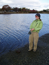
I was lucky enough to have the experience of exploring Ireland with Josh. It was everything I could ever want in an adventure-great company and great scenery. We took the ferry from France to Cork and immediately made our way northwest to the Dingle Peninsula. Our first hike took us around the western tip of the peninsula. We parked at a cemetery and started at Ventry Harbour along the beach.
 Beach at Ventry Harbour.
 A very nice place for a final resting spot.
 After walking the curvature of the beach, we cut upwards through farm roads. We walked along sea cliffs and then took the main road leading to Slea Head for a few kilometers before going back to dirt and grass roads.
 Rocky coastline along southern margin of Dingle peninsula.
 By paying a friendly farmer six Euros, we were allowed to cut up rock-lined farm roads, ever gaining elevation towards the summit of Mt. Eagle (elev. 516m). The farmer charged because his property contains the remains of several famine cottages of the 19th century that he maintains for display. The Dingle Peninsula was hit especially hard by the Great Famine of 1845-1852, partly due to its remote and isolated location. The roads to Slea Head and Connor Pass were built in the 1800s as part of relief efforts, but the soup they were rationed daily contained less calories than they expended in road building activities1. The cottages are made-up to look like the mid-1800s, and it is very eery because you will duck into a dark cottage and a whole wax family of starving peasants will be huddled inside.
Thankful for our Nutella and tortillas, we stopped and had lunch along the farmers road that was gaining us access up the mountain side.
 Lunch along a rock-lined farm road. Also the last place we saw Josh's sunglasses.
There were plenty of sheep to keep us company. Besides a farmer and his border collie rounding up sheep, bringing them down in the afternoon, we didn't see anyone for the entirety of our hike.
 This is how you know you're in Ireland.
The fields are an intricate patchwork of stacked rock walls. It is a beautiful man-made alteration of the landscape. These rock walls have likely been maintained in their current pattern for numerous centuries.
 The farmer's fields we hiked through.
Ireland is known for its diverse botanical species and amazing micro-communities of plants tucked down in between rocks, or in crevices along the margins of streams. Pictured below is a small, unique community of plants inhabiting a small niche in the rocks. These species didn't exist across the rest of the landscape, only sporadically in a small crevice here or there.
 A small niche of unique and beautiful plant organisms.
 We finally summit Mt. Eagle towards the end of the afternoon and hiked down the backside of the mountain, descending through partially cut peat bogs, around Eagle Lake, through a small community and then out to the main road and back to the cemetery. What a day! That evening we went to a small local pub, drank Guinness, listened to folk music with the locals and made friends with some real characters.
 View from Mt. Eagle summit.
Another all-day, 20 km +, mind blowing hike we did was located in the area known as The Burren. This landform is an expanse of gray limestone cliffs and pavement on the central west coast of Ireland. The name Burren comes from the Irish word boireann, meaning 'place of rocks'1......hmmm, fitting. The limestone of this landscape is approximately 340 million years old and formed from the shells and skeletons of marine creatures that dissolved in the warm, shallow sea that once covered future Ireland. The Burren limestone is up to 780 m thick and is exposed due to glacial scouring and subsequent erosion caused from forest removal by early farmers. The limestone beds are water-soluble and contain cracks and joints that allows water to seep downwards and sideways. As rainwater widens and deepens the cracks, an elaborate network of hollows, channels, pinnacles and underground cave formations, called karsts, are formed1.
 Limestone expanses of The Burren.
 Stone Fort Cathair Dhuin Irghuis.
 The outer round wall of Cathair Dhuin Irghuis.
 Shambled entrance to fort Cathair Dhuin Irghuis.

 Limestone expanses of The Burren.
People have been inhabiting The Burren for at least 5000 years. The earliest people of the Neolithic and Bronze ages built large megalithic tombs, or dolmens. Dolmens consist of enormous, upstanding slabs that form wedge-shaped or rectangular burial chambers supporting a massive lid or capstone. Sometimes all that remains of these structures, after the capstone has fallen, are 3-7 upright stones or legs. Later, around 600 BC, Celtic people settled in the area and built round or oval enclosures. By 300 AD, the forest had been opened up to allow for more grassland and grazing. Extensive forested areas remained standing before the 15th century but population later increased and the demand for timber saw the forests completely removed1.
The first ruin we came across during hiking the Burren was the stone fort of Cathair an Aird Rhois. I am not sure how old it is, but I guess Iron Age (1000 BC-400 AD) or younger. It is amazing how straight the walls are, how carefully each stone is placed. And in case the archaeology police are concerned, all this information is published in the hiking guide book cited at the bottom of the page.
 Cathair an Aird Rhois Stone Fort.
 Doorway to one of the fort structures. If you put your eye to the edge of the wall, all
After the fort, we hiked long expanses of the limestone pavement. Farmers had stacked rows of large, fractured pieces of limestone for fences. It was hard to tell if some isolated clusters of upright rocks were remains of megalithic tombs or not. I did not want to investigate very much, content to enjoy the impressive scenery of the landscape.
 Stacked limestone fence.
 Impressively stacked rock cairn.
 Dobhach Brainin rock cairn.
 Dobhach Brainin rock cairn.
The first ruin we came across during hiking the Burren was the stone fort of Cathair an Aird Rhois. I am not sure how old it is, but I guess Iron Age (1000 BC-400 AD) or younger. It is amazing how straight the walls are, how carefully each stone is placed. And in case the archaeology police are concerned, all this information is published in the hiking guide book cited at the bottom of the page.
 Cathair an Aird Rhois Stone Fort.
 Doorway to one of the fort structures. If you put your eye to the edge of the wall, all
 the stones lined up perfectly, as seen on the right side of the doorway. Amazing!
After the fort, we hiked long expanses of the limestone pavement. Farmers had stacked rows of large, fractured pieces of limestone for fences. It was hard to tell if some isolated clusters of upright rocks were remains of megalithic tombs or not. I did not want to investigate very much, content to enjoy the impressive scenery of the landscape.
 Stacked limestone fence.
We eventually came to the northern edge of Black Head that runs above the waters of Galway Bay. There we observed a large, triangular shaped rock cairn that was an impressive example of oppositional force.
 Impressively stacked rock cairn.
Atop one of the small, unnamed summits along our hike was the large rock cairn of Dobhach Brainin, possibly of Neolithic origin.
 Dobhach Brainin rock cairn.
  Dobhach Brainin rock cairn.
 Continued hiking west towards Black Head brought us to the Iron Aged, round-walled ruins of the stone fort Cathair Dhuin Irghuis. It was too perfect that a single, beautiful, pink, Hyacinth-like flower grew in the center of the structure.
 Stone Fort Cathair Dhuin Irghuis.
 The outer round wall of Cathair Dhuin Irghuis.
 Shambled entrance to fort Cathair Dhuin Irghuis.
We were only able to explore a few areas of Ireland, but what we saw was breathtaking. I could 'waste' huge portions of my life doing nothing but this.....hiking around looking at interesting history, archaeology and geology. I will return someday to explore this emerald isle more thoroughly. And the sun sets on the western shore of Ireland.

1 Bardwell, S., H. Fairbairn and G. McCormack
2003 Walking in Ireland. Loneley Planet Publications, Melbourne, Australia.
2003 Walking in Ireland. Loneley Planet Publications, Melbourne, Australia.
No comments:
Post a Comment